Saeid Delnavaz
Computer Scientist and GIS Analyst
Welcome and thank you for visiting my website. I am an experienced GIS Analyst and Computer Scientist with a extensive knowledge of spatial analysis, digital image processing, programming, and computer applications.
Online Maps
The following online maps demonstrate my ArcGIS Online skills and were created for the Chicago Metropolitan Agency for Planning
Local Technical Assistance (LTA) Projects
Major Capital Projects
Northeastern Illinois Counties 1980 to 2014
Resume
Education
Chicago State University
(Chicago, IL)
2017 - current
Master of Computer Science
Chicago State University
(Chicago, IL)
2013 - 2015
Master of Geography- GIS concenteration
Azad University-South Tehran Branch
(Tehran, Iran)
2003 - 2007
Bachelor of Civil Engineering –Surveying concentration
Experience
ComEd
(OakBrook, IL)
Jun 2016 - July 2017
GIS Analyst
- Leveraging GIS to conduct quality control reviews.
- Analyzing possible solutions regarding digitizing Underground Distribution Assets.
- Analyzing multiple data source points.
- Producing production reports.
Mobilitie
(Chicago, IL)
Dec 2015 - Jun 2016
GIS Specialist
- Analyzing data to determine the best locations for future telecom development.
- Testing data for quality and completeness and creating reports on those audits.
- Writing reports and communicating results.
- Collaborate with a team to solve complex problems.
Chicago Metropolitan Agency for Planning (CMAP)
(Chicago, IL)
May 2015 - August 2015
GIS Intern
Research and Analysis Division
- Geo-referencing historical aerial photographs of the northeastern Illinois counties region using ESRI’s ArcGIS software.
- Enter metadata into Access database.
- Creating interactive online maps for different projects.
- Importing, editing and designing data in ArcGIS online.
- Customizing various ArcGIS Web Apps by utilizing Web AppBuilder.
- Updating attributes in DTA (Dynamic Traffic Assignment) network.
Chicago State University
(Chicago, IL)
Feb 2014 - May 2015
Graduate Research Fellow
Minorities and Retirement Security Program
- Extracting, cleaning, and combining geospatial data from multiple sources such as census and local governments.
- Making various maps of combined data by utilizing geoprocessing tools (buffer,clip,intersect, etc) in QGIS and Arc Map.
- Utilizing GIS to analyze the retirement security issues of the low income minorities in Chicago.
- Presenting my findings at monthly seminars.
Inner-City Muslim Action Network (IMAN)
(Chicago, IL)
Nov 2013 - May 2015
GIS Analyst and Field data Collector
The geography of corner stores in an inner-city African American Chicago neighborhood
- Conducting a survey and collecting data from corner stores in Englewood community area.
- Geocoding, editing, integration and designing data using Arc Map.
- Testing automated outputs.
Chicago Food Security Alliance
(Chicago, IL)
Oct 2013-Dec 2013
GIS Analyst
- Redesigning and editing an existing map for Food Pantry Network of Chicago.
- Creating appropriate symbology, map elements, and layout design.
- Geodatabase maintenance and troubleshooting.
Nimrokh Company
(Tehran, Iran)
April 2009 -May 2011
Land and Underground Surveyor Technician
- Utilizing Total Stations to measure horizontal and vertical angles.
- Using GPS devices to collect data plus designing and drafting them in AutoCAD.
- Utilizing QGIS and Arc Map to assemble and analyze data.
- Importing, exploring, manipulating and exporting tabular data in SQL Server.
- Interact and work effectively with coworkers from different backgrounds.
Skills
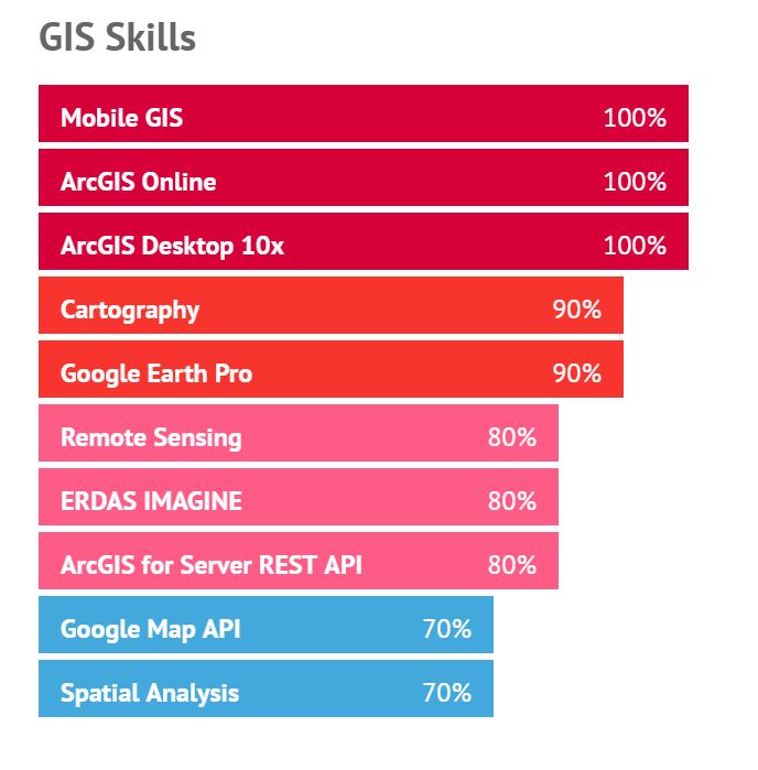
GIS Skills
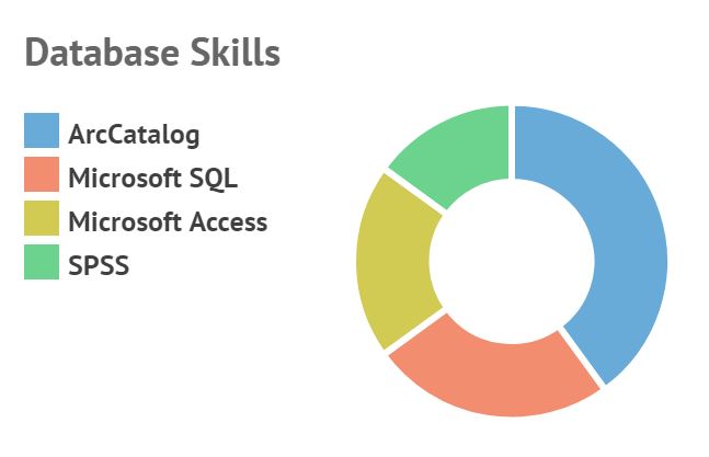
Database Skills
- ArcCatalog
- 40
- Microsoft SQL
- 25
- Microsoft Access
- 20
- SPSS
- 15
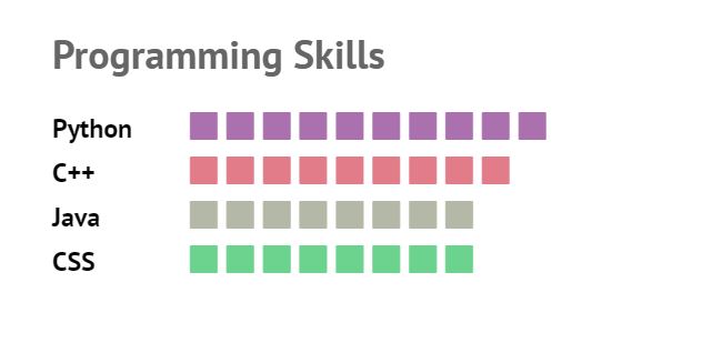
Programming Skills
- Python
- 10
- C++
- 9
- Java
- 8
- CSS
- 8
Other Skills
- Microsoft Office
- 20
- Web Design
- 20
- Auto Cad
- 15
- Photoshop CS
- 15
- Leica TS06, 805
- 10
- GPS (Garmin)
- 10
- Photoshop Lightroom
- 10
Honors and Awards
NEXTRANS Fellowship (2015)
Chicago State UniversityGamma Theta Upsilon Honor (2015)
Gamma Theta Upsilon (GTU)Departmental Merit Award (2015)
Chicago State University (GTU)Urban Agriculture, Urban Ecology and Aquaponics Fellowship (2014)
Chicago State UniversityMinorities and Retirement Security Program Grant (2014)
Chicago State UniversityConference Travel Grant (2014)
Chicago State University
Events
| Date | Event | Location |
|---|---|---|
| 2015-04-21 | Association of American Geographers (AAG) Annual Meeting 2015 |
Chicago, IL |
| 2014-09-12 | GIS in Public Health |
Chicago, IL |
| 2014-04-08 | Association of American Geographers (AAG) Annual Meeting 2014 |
Tampa, FL |
| 2014-03-14 | Nokia Student Symposium |
Chicago, IL |
| 2013-11-05 | Sharpen Your GIS Skills Seminar- ESRI |
Chicago, IL |
Certificates
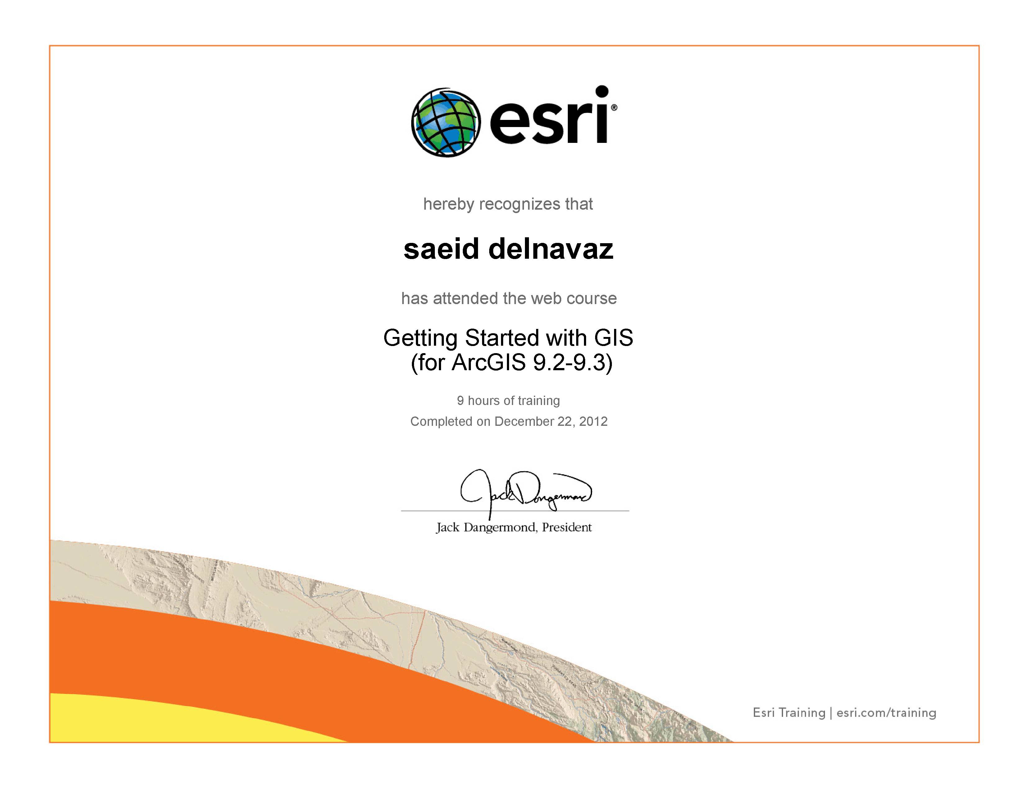
Course objectives
1.Display geographic data in ArcMap
2.Use analysis tools to create new data
3.Apply a standard approach to solving geographic problems
4.Understand different types of spatial relationships among real-world features.
5.Query a GIS database to gain information and locate features.
Getting Started with GIS (for ArcGIS 9.2-9.3)
This course provides a foundation for understanding what a geographic information system is and the possibilities it offers for discovering patterns, relationships, and trends. I learned how GIS maps are different from other types of paper and digital maps, what makes the data used in a GIS unique, and how to use GIS software to obtain information and create meaningful maps.

Course objectives
1.Display data on a GIS map
2.Query a GIS database to gain information and locate features on a map
3.Understand different types of spatial relationships among real-world features
4.Use analysis tools to create new data
5.Apply a standard approach to solving geographic problems
Getting Started with GIS (for ArcGIS 10.1)
This course helped me understand what a geographic information system is and why organizations around the world rely on GIS technology. In course exercises and activities, I worked with ArcGIS software and saw how a GIS supports problem solving in many different contexts.

Course objectives
1.Increase productivity using new ArcMap features, including the embedded Catalog window, symbol search, and basemap layers
2.Incorporate enhanced cartographic capabilities into your maps, such as dynamic layout text, data driven pages for creating a map series, and access to professionally designed basemaps
Using ArcMap in ArcGIS Desktop 10
ArcGIS 10 brings many enhancements to ArcMap that help you produce and share better maps faster. In this course, I learned about key new features that are designed to reduce the time spent on common mapping tasks and improve the quality of my map products. In the presentation I learned how I can take advantage of these new features to enhance my day-to-day workflows.
Course objectives
1.Edit with feature templates
2.Work within the new snapping environment
3.Follow new editing workflows
Editing in ArcGIS Desktop
The improved editing environment in ArcGIS Desktop 10 features a reorganized editing interface that offers easier access to tools. This course introduces new streamlined editing workflows, which provide a more intuitive experience and allow for quicker completion of data editing tasks.
Course objectives
1.Describe why the shape used to model the earth is important for GIS mapping and analysis
2.Understand how the system of latitude-longitude locates features on the earth's surface
3.Convert latitude-longitude units to decimal degrees
4.See how the choice of geographic coordinate system affects feature locations and measurements on a GIS map
Basics of Geographic Coordinate Systems
How do you accurately represent the location of features found on the earth’s three-dimensional surface on a two-dimensional piece of paper or computer screen? In a GIS, the answer starts with a geographic coordinate system. In this course, I learned the fundamental concepts of geographic coordinate systems and some of the history behind their development. I also see how improvements in technology have affected the accuracy of GIS maps and measurements made from them.

Course objectives
1.Publish hosted feature services and tiled map services to ArcGIS Online
2.Quickly create and configure a web map using the ArcGIS Online map viewer
3.Use an ArcGIS Online template to easily share a web map as a web app
4.Choose appropriate sharing levels to accommodate the intended users of a web map or web app
Authoring Web Maps Using ArcGIS Online
Organizations use ArcGIS Online to facilitate collaboration and efficient access to maps and other GIS resources. This course shows how to publish data and map layers directly to ArcGIS Online as services, then use those services to quickly build a web map.I also learned how to turn a web map into a web app to provide a focused experience formy audience.

Course objectives
1.Use the REST API Reference to understand the parameters, input values, and syntax required to perform operations on a service
2.Test services to verify they perform as expected
3.Apply a standard process to troubleshoot unexpected service errors
Introduction to the ArcGIS for Server REST API
This course helped me to understand what the ArcGIS for Server REST API is and how it helps me find GIS resources, discover their capabilities, and put them to use in my own maps and apps. You learned how the REST API translates seemingly complex client-server communications into a friendly format I can easily interpret and leverage when working with other Esri products and applications.

Course objectives
1.Choose the Python scripting environment that meets your needs
2.Choose appropriate data types and apply Python syntax rules when writing a script
3.Label map features using a Python expression
4.Understand common types of errors and how to correct them.
Python for Everyone
Python is the scripting language of choice for the ArcGIS platform. This course introduced fundamental Python concepts and the Python scripting environment in ArcGIS. Tips and techniques to help my master proper Python syntax, script flow, and error handling were presented.

Course objectives
1.Create basic Python scripts using correct syntax
2.Write and run scripts in ArcMap using the Python window
3.Use Python in the Field Calculator
4.Create script tools to automate geoprocessing operations
Using Python in ArcGIS Desktop 10
At ArcGIS Desktop 10, Python scripting is tightly integrated into ArcMap and ArcCatalog, allowing you to create and automate GIS workflows quickly and easily. This course introduces Python scripting in ArcGIS Desktop and shows how I can use scripts to increase productivity and the quality of my maps and data. I also learned how to use the new ArcPy mapping module to manipulate map documents and layers.
Course objectives
1.Access web maps shared using the ArcGIS for iOS application
2.Search for map features and access information about them
3.Measure distances and areas on a web map
4.Collect and edit data in the field using the ArcGIS for iOS application
5.Attach a photo to a map feature
Mobile GIS: Using the ArcGIS for iOS Application
I learned how to access and work with web maps shared using the free ArcGIS for iOS application. Providing access to GIS-enabled web maps allows iPhone, iPad, and iPod touch users to explore data hosted on your server or on ArcGIS Online; discover information in interactive, visually rich maps; and collect and update GIS data in the field—which in turn can streamline your data collection workflows, promote citizen engagement, and help increase the currency of your GIS database.
Contact
Where I Am Based
Get in Touch
| ssdelnavaz@gmail.com | |
| www.saeiddelnavaz.com |